Forecasters monitor Gulf disturbance that could increase weekend rain
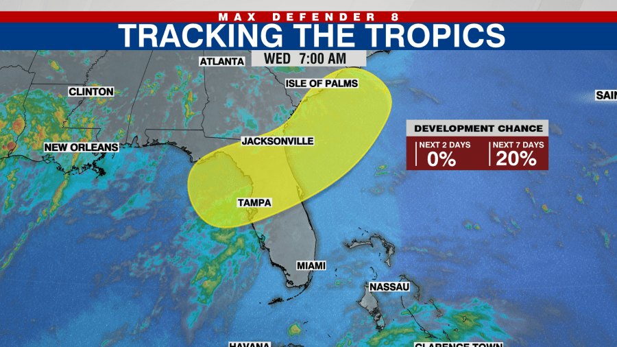
The National Hurricane Center is monitoring a low-pressure system expected to develop in the northeastern Gulf of Mexico that could bring increased rain and gusty winds to the Tampa Bay area, including Clearwater, as early as the weekend of July 18-19.
The disturbance has a 0% chance of tropical development during the next 48 hours and a 20% chance over the next seven days, according to the National Hurricane Center's Wednesday, July 15, outlook.
WFLA meteorologist Amanda Holly said a stalled front moving into the northwestern Gulf this weekend, combined with a trough lifting north from Cuba and abundant tropical moisture over warm Gulf waters, could support "low-end tropical development late this weekend into next week."
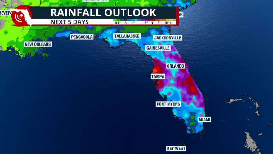
Holly said the system is expected to increase rain chances and produce breezy to gusty conditions across the Tampa Bay area while it remains nearby. She said forecasters should have a clearer picture of the system's track and development potential by Friday, July 17.
According to Fox Weather, the National Hurricane Center's monitoring area extends from the Gulf waters off Florida's Big Bend across the Florida Peninsula and along the coasts of Georgia and South Carolina. Even if the system does not become a tropical cyclone, portions of northern Florida and the southeastern United States could receive periods of heavy rain.
First Gulf system to draw attention this season
The disturbance is the first Gulf system near the Tampa Bay area to be highlighted by the National Hurricane Center during the 2026 Atlantic hurricane season.
The season's only named storm so far, Tropical Storm Arthur, formed in the western Gulf of Mexico before making landfall near Matagorda, Texas, in mid-June.
Earlier this month, Colorado State University revised its seasonal outlook downward, forecasting a "well below normal" Atlantic hurricane season with nine named storms, four hurricanes and one major hurricane. Researchers cited a strengthening El Niño pattern as the primary reason for the reduced forecast.
However, Colorado State University hurricane researcher Philip Klotzbach cautioned that Gulf Coast storms are often less affected by El Niño-related wind shear than storms that develop in the Caribbean Sea or eastern Atlantic Ocean.
"It's important to be prepared since it only takes that one storm near you to make it an active season," Klotzbach said.
Residents encouraged to review hurricane plans
Pinellas County Emergency Management encourages residents to know their evacuation zone, develop a hurricane plan and stay informed throughout the season.
Residents can find their evacuation zone at kyz.pinellas.gov or call (727) 464-3800. The county's 2026 Hurricane Guide is available online and at Pinellas County libraries.
Officials also remind residents living in mobile or manufactured homes that they should evacuate whenever an evacuation order is issued, regardless of their evacuation zone.
The National Hurricane Center updates its Graphical Tropical Weather Outlook several times each day on its website.
.jpg)