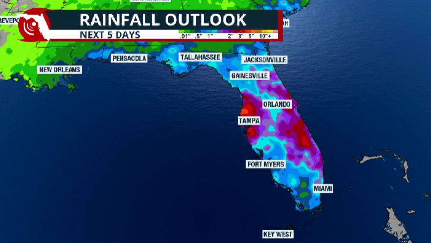
Clearwater and the Tampa Bay area could see 3 to 5 inches of rain through Thursday, July 30, as a surge of tropical moisture collides with a stalled frontal boundary, creating repeated rounds of heavy thunderstorms and increasing the risk of flash flooding. The same weather pattern could also produce isolated severe storms capable of damaging wind gusts of at least 58 mph.
Some Gulf Coast communities, including Tampa Bay, are forecast to receive between 3 and 5 inches of rain from Monday, July 27, through Thursday, July 30, according to a forecast issued Monday by Florida Public Radio Emergency Network meteorologist Irene Sans and published by WMNF 88.5 FM.
The unsettled pattern is being fueled by deep tropical moisture moving north from the Gulf and Caribbean interacting with a weak frontal boundary lingering across the Southeast. That combination is expected to keep rain and thunderstorm chances well above normal across West Central Florida through at least Thursday.
"High rainfall amounts could fall over the same areas repeatedly or within a short amount of time, which could trigger flash flooding," Sans said in her forecast.
Slow-moving storms tracking west to east across Central Florida could repeatedly drench the same neighborhoods, increasing the likelihood of flash flooding. Isolated severe thunderstorms capable of producing wind gusts of 58 mph or higher are also possible. On Monday, July 27, FPREN forecast storms developing along the Interstate 4 corridor between Tampa and Orlando from late morning into the afternoon.
Extreme drought could worsen runoff
The heavy rain arrives after months of unusually dry weather across much of the Tampa Bay region.
Sans reported that areas stretching from Tampa Bay south to just north of Punta Gorda remain in extreme drought. Dry, hardened soil often absorbs rainfall more slowly than moist ground, increasing runoff and raising the risk of street flooding and flooding in low-lying areas during intense downpours.
Flood advisories were issued across parts of Central and South Florida on Sunday, July 26, as thunderstorms developed ahead of the main weather system, according to FPREN.
How Pinellas County residents can prepare
Sans urged residents to avoid driving through flooded roadways, especially in locations that frequently flood.
Pinellas County Emergency Management recommends residents:
- Know their flood risk by visiting floodmaps.pinellas.gov, selecting "My Flood Risk," and entering their address.
- Sign up for Alert Pinellas emergency notifications or download the free Ready Pinellas app for real-time weather and emergency alerts.
- Follow @PinellasEM and @PinellasGov on social media and monitor forecasts from the National Weather Service Tampa Bay office for watches and warnings.
Residents also can call Pinellas County Emergency Management at (727) 464-3800 or visit disaster.pinellas.gov for evacuation zone information and preparedness resources.
The National Weather Service Tampa Bay office will issue any flash flood watches or warnings affecting Pinellas County through Thursday.
.jpg)